



Southern California is preparing for a dramatic change in coastal conditions this Labor Day weekend as Hurricane Marie moves across the eastern Pacific, sending powerful swells, increased humidity and tropical moisture toward the region.
As of Friday morning, September 4, Hurricane Marie was located about 550 miles west southwest of the southern tip of Baja California with maximum sustained winds of 100 mph. The storm was moving west northwest at about 9 mph. The National Hurricane Center said Marie is moving away from land and no coastal watches or warnings are currently in effect.
Although the center of the hurricane is expected to remain well offshore, Southern California will still feel noticeable effects from the system over the coming days.
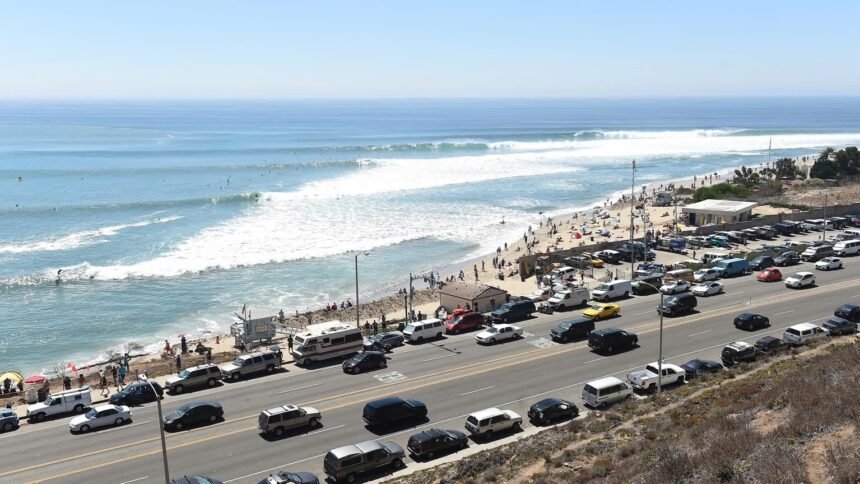
The National Weather Service in Los Angeles said Marie is expected to bring increasing southerly swells to the coast, creating hazardous surf conditions during one of the busiest beach weekends of the year. Forecasters expressed high confidence in the potential for dangerous rip currents and large waves, particularly at south facing beaches.
The timing could be especially important for families and visitors planning to spend Labor Day weekend along the coast.
Forecasters expect a south swell of approximately six to eight feet in some areas, while higher tides are expected to begin Saturday and peak Monday and Tuesday. Tides could rise above seven feet in some coastal locations.
Beaches throughout Los Angeles and Orange counties could experience unusually powerful waves and strong currents even when conditions appear calm from shore.
Communities including Malibu, Santa Monica, Manhattan Beach, Huntington Beach, Newport Beach, Laguna Beach and other south facing coastal areas could see elevated surf conditions as energy from Marie reaches Southern California.
The National Weather Service is urging inexperienced swimmers to stay close to lifeguards and warning beach visitors that rip currents could become potentially deadly.
Orange County and San Diego County are also preparing for impacts.
The National Weather Service office in San Diego said surf generated by Marie is expected to begin arriving Friday night and peak Sunday before gradually declining Monday into Tuesday. That forecast covers Orange County, San Diego County, western Riverside County and southwestern San Bernardino County.
The ocean will not be the only place where residents may notice Marie.
Tropical moisture associated with the hurricane is expected to move north into Southern California, increasing humidity and bringing chances for showers over portions of the region.
The Los Angeles area has the greatest chance for rain on Sunday, according to the National Weather Service. Forecasters expect the hurricane itself to remain far offshore while moisture from the system interacts with Southern California weather patterns.
The San Diego forecast also calls for the greatest chances of showers on Sunday as mid and high level moisture connected to Marie moves into the region. Warmer and gradually drier conditions are expected to return between Monday and Wednesday.
For Southern California residents accustomed to dry late summer weather, the combination of clouds, tropical humidity, rain chances and elevated surf could give the holiday weekend an unusually tropical feel.
The Los Angeles region is also experiencing temperatures below normal for this time of year following several periods of intense summer heat. The National Weather Service expects cooler conditions and breezy onshore winds to continue before moisture from Marie becomes more noticeable.
Offshore waters are expected to become increasingly rough as well.
National Weather Service marine forecasts show seas building through the weekend, with portions of the outer Southern California coastal waters potentially seeing seas of six to nine feet Saturday night and Sunday night.
Boaters, surfers and anyone planning ocean activities should closely monitor conditions before heading onto the water.
Marie is currently a powerful hurricane, but its projected path remains well west of Southern California. The National Hurricane Center said Friday morning that the storm was moving away from land, significantly reducing the threat of a direct hurricane strike on California.
Instead, the biggest concern for Southern California is the distant storm’s ability to generate waves that travel hundreds of miles across the Pacific before reaching the coastline.
These long period swells can produce powerful breaking waves and rip currents even while skies remain relatively calm, making ocean conditions more dangerous than they may appear.
The timing coincides with Labor Day weekend, traditionally one of the busiest periods of the summer season for Southern California beaches.
From Santa Barbara County through Los Angeles, Orange County and San Diego, thousands of residents and tourists are expected to visit the coast.
Forecasters are advising beachgoers to choose areas staffed by lifeguards, pay attention to warning signs and avoid entering the ocean when conditions become dangerous.
The National Weather Service is also continuing to monitor the possibility of thunderstorms as tropical moisture arrives. Exact rainfall totals and locations could change depending on the eventual movement of moisture surrounding Marie.
For now, the message from forecasters is clear. Southern California is not expecting a direct hit from Hurricane Marie, but the storm will still make its presence felt.
Powerful surf, dangerous rip currents, unusually high tides, tropical humidity and a chance of rain could transform the coastline throughout the holiday weekend.
Residents planning a Labor Day beach trip should check the latest forecast before leaving home and follow instructions from lifeguards and local authorities.
Marie may remain hundreds of miles offshore, but by this weekend, its effects could be visible from beaches across Southern California.